Revolutionize your trading with the 1inch App! Enjoy gasless swaps, exceptional rates, and a user-friendly interface. Take control of your crypto journey—download now!

Skip to main content

Klimweek: Randa Cura, Sa Calobra, Sobremunt en de top van de Puig Major

Wat maakt deze week zo bijzonder?

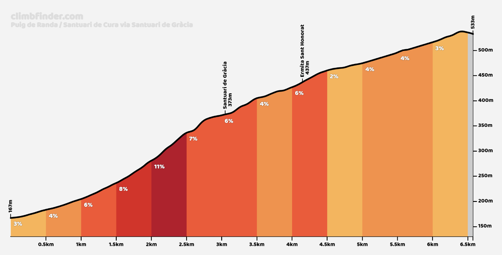
1. Clinic op Randa Cura: We beginnen de week met een klim & daal-clinic op Randa Cura.
Je ontvangt deskundige tips en technieken om je klimvaardigheden te verbeteren, terwijl je geniet van het prachtige landschap.

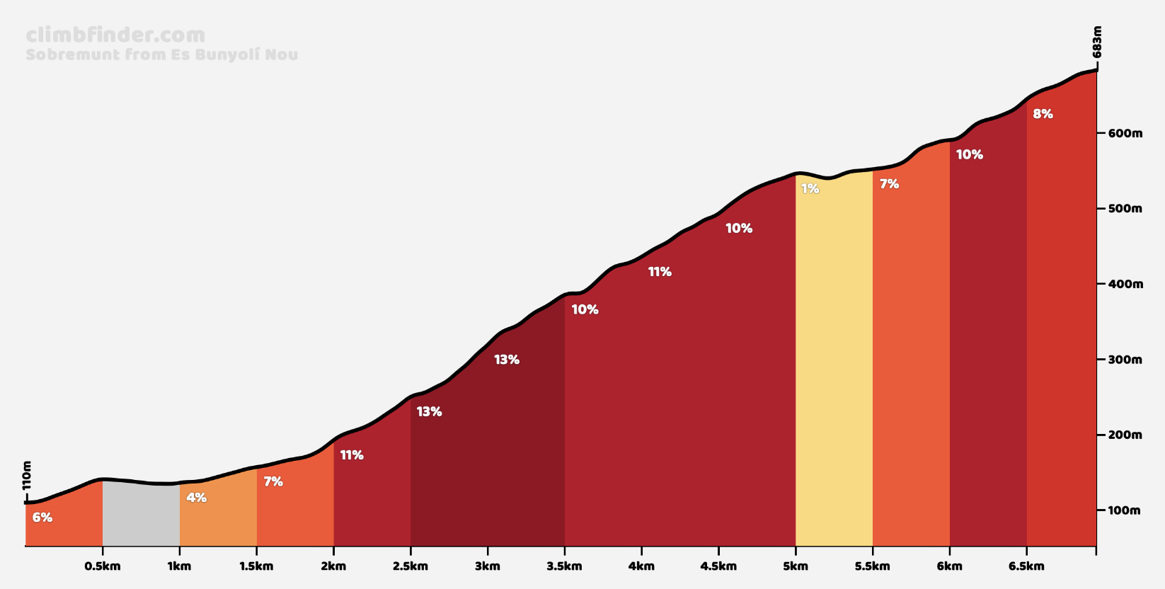
2. Sa Calobra en Sobremunt: Ga de uitdaging van de Sobremunt aan, de beruchste en steilste klim van Mallorca.
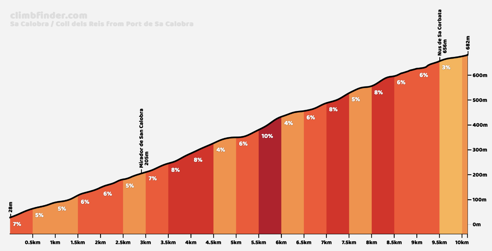
En ook de iconische beklimming Sa Calobra staat natuurlijk op het programma.
Deze móet je beklimmen als je op Mallorca bent. Een prachtige klim met een van de mooiste uitzichten van Mallorca.
3. Puig Major Beklimming – Top: Het hoogtepunt van onze Klimweek is de epische beklimming van de Puig Major.
Maar hier wordt het pas echt uniek, – we hebben speciaal voor jou een getimede Puig Major-dag op zaterdag tijdens jouw deelname aan het evenement La Pérez.
Normaal kun je tot 800 meter hoogte klimmen, maar tijdens dit event kun je doorgaan tot de echte top naar ruim 1400 meter hoogte.

Sobremunt

  • Length: 7 kilometres.
  • Average Gradient: 10%.
  • Toughest Gradient: 25%.

Sobremunt is a relatively unknown climb but amongst those in the know, it has the reputation of being the toughest in Mallorca when it comes to gradients and road surface.

You will find a small sign with the name of the climb (Sobremunt) that points towards a right turn out of the Ma-1041 road. From here the road starts to climb. It’s here that most consider Sobremunt to start. You will be 7 kilometres from the top although the first 2 are pretty gentle. Steady gradients of around 3%, hide the true nature of the incline in the following kilometres.

It’s at 5 kilometres from the summit that the climb starts to bite. Short short ramps of up to an eye watering 20% kick in. This is followed by beautiful but nasty hairpins made even tougher by the terrible state of the road filled. Thankfully, dense walls of Mediterranean pine trees laying at both sides of the road offer protection from the sun during most of the steepest sections.

After a brutal first kilometre of proper ascent you will find a few meters of respite before kicking up again into a relentless second and third kilometres where the gradients barely drop from 10%. There’s the occasional short descent that allows for a breather before the road gets back at you with the next gruelling section.

1.5 kilometres from the top you will have to cross a gateway on the right hand side. By this point the road surface becomes a mix of worn-out tarmac and gravel while the gradients keep averaging 10% maxing out at 18%. You will need all your bike handling skills as you grind your way to the top

Randa

  • Length: 4.75 kilometres.
  • Average Gradient: 5.3 %.
  • Toughest Gradient: 8 %.

Leaving the Ma-5010 road between Llucmajor and Algaida you’ll get immediately arrive at Randa. The road begins heading up on a 5% gradient a few hundred meters before the official Strava segment. The climb proper starts off right at the beginning of the Ma-5018 road with a signpost indicating “Santuari de Randa”.

After passing by a cafe popular with cyclists, the first few meters run through the narrow quaint streets of Randa surrounded by picturesque old buildings. You won’t have much time to appreciate the architecture and in a matter of a few pedal strokes you will be out of town.

The first part of the climb has a couple of steep ramps but quickly eases into the average 5% gradient for most of the ascent.
After the first kilometer you will notice a diversion on the right side of the road that allows you to climb to Puig de Randa through another road. It’s a significantly tougher alternative route with a kilometre and a half at 9% and steep ramps up to 13% over a much narrower surface.

The scenery is nothing outstanding until kilometre 2 of the climb, when you’ll reach a narrow hairpin where the view opens to the valley and for the first time you’ll be able to spot the Mediterranean sea in the distance. It’s quite a sight as the flatlands dominate this part of Mallorca.
After the hairpin the road offers a brief rest section and kicks up again with easier gradients from here to the summit. From kilometre 3 onwards you’ll get panoramic views all the way to the top of the climb.

Puig de Randa is not only the highest elevation point in Mallorca outside of the Tramuntana mountains but it’s also the highest for miles around it. It naturally offers jaw-dropping panoramic views of the distant mountains and sea.
You’ll know you are almost at the top when you spot the prominent radar station tower, the famous landmark. There’s a signpost indicating the summit at 534 meters of altitude and a few meters ahead you’ll find the famous Santuari de Cura. The sanctuary has been lovingly restored into a boutique hotel and restaurant but if you don’t want to stay, you can still explore the stunning stone courtyard and relax in almost complete isolation.

Sa Calobra

  • Length: 9.5 kilometres.
  • Average Gradient: 7%.
  • Toughest Gradient: 12%.

the Sa Calobra climb is located in the Tramuntana mountains. It features almost endless picturesque switchbacks and a rocky moon-like landscape overlooking the Mediterranean sea. It’s quite remote, you can only reach the port by boat or by descending Sa Calobra, but that makes it all the more special.

The starting point of Sa Calobra climb is its namesake village nestled among monumental cliffs edging the pristine waters of the Northern Mallorca coast. There is no other road to access the climb, but the climb itself. That makes Sa Calobra a route that you will have to descend before you get to ride it uphill for the first time (unless you arrive at the starting point by boat). It also involves a substantial dose of climbing before you even get to it.

The road kicks off with the easiest of gradients, slowly making its way up a beautiful valley enclosed between vertical limestone walls. Don’t get fooled by these initial ramps and keep a pace that you can sustain for at least an hour as the ramps will get sharper further ahead. After 2.5 kilometres you’ll find one of the main highlights of this beautiful climb, the rocks seem to swallow the narrow strip of tarmac as you make your way across Sa Bretxa, an impressive natural arc with just enough space for one bus to pass through.

It’s not until kilometre 6 that the real hairpins kick in, unleashing a dizzying number of twists and turns over the increasingly exposed terrain. This part of the climb surely is among the most scenic segments of road to ride a bicycle, anywhere in Europe. The scenery and the viewpoint changes every few meters and the imposing calm of the Mediterranean sea provides a magnificent backdrop.

If you chose to push it hard up to this point, you better have saved something in the tank for the last 3 kilometres since they will be the toughest of the climb. The hardest section of the climb is actually between kilometres 7 and 8, with hairpins coming thick and fast, and the average gradient increasing. That, added to the fatigue accumulated over the whole climb, will make you struggle to reach the top if you haven’t paced yourself from the beginning.
The very last hairpin it’s also the most iconic – Nus the Sa Corbata (literally meaning “Tie knot”). It’s the famous photo of Sa Calobra and features a 270-degree turn with the road bending over itself. From there it’s just a 500 meters sprint up to the top of the climb.

Coll de Sa Creu

  • Length: 5.8 kilometres.
  • Average Gradient: 5.3%.
  • Toughest Gradient: 9%.

Climbing Coll de sa Creu from Palma is a popular route from Mallorca’s capital into the Tramuntana mountain. Heading up the Ma-1043 road, the climb starts relatively easy, but the going gets a bit tougher around the bends at kilometer 4.

To our left we leave the military terrain. This start has a difficulty between 3 and 5%. If we start from Palma de Mallorca we pass from the Ma-1042 to the Ma-1043 in the village of sa Teulera.

The port is quite narrow but is in perfect condition. In its route there is usually little traffic, which is appreciated in an island as overcrowded with vehicles as the island is.

Once we have left behind the barracks, we have on the margins of the road a wooded area of pine trees that will accompany us at all times.

This initial phase is quite straight. Once past the barracks there is a slight (and short) descent so that the ascent is positive again until the summit.

At 5 kms. to the top of the hill, the route begins to undulate, with a somewhat demanding first km. at 6%.

Then the next 2 kms. have a consistent average of around 7%, with a maximum stretch at 8% close to 3 kms. to crown.

Before overcoming the Coll de sa Creu we make 10 spectacular horseshoe curves, most of them accumulated in the last km. of the aforementioned pass.

There is no sign indicating any of the passes. It is intuited when descending towards the town of Calvià.

The stretch of just one km. between the coll de sa Creu and the coll des Vent initial 4% to finish the port between 6-7%.

Finally we crowned the pass taking as reference the unwritten signpost that we see in the image at an altitude of 380 mts.